

Master Global Political Geography and Accelerate World Map Recall with SST – World Countries A4 NTR Map
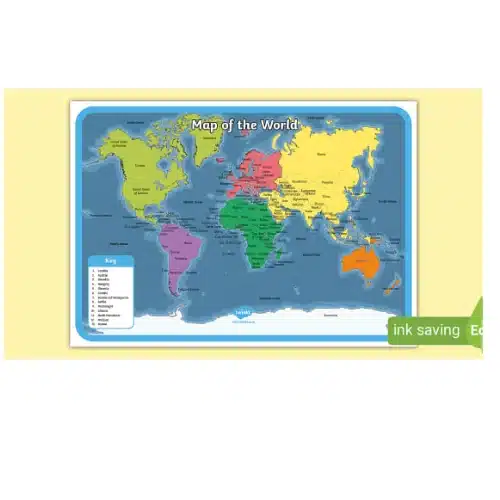
Eliminate international boundary confusion, memorize sovereign capitals and geopolitical regions effortlessly, and score higher in social studies and competitive general knowledge examinations with our SST – World Countries A4 NTR Map. Designed specifically for K-12 students, UPSC aspirants, and geography faculty, this heavy-duty educational map provides learners with an instant, colour-differentiated cartographic overview of global sovereign states. Furthermore, crisp border demarcations, clearly marked strategic maritime straits, and high-contrast cartographic typography transform extensive world geography into an intuitive, easily accessible desk companion.
Discover professional-grade synthetic sheet printing and complete academic customisation solutions with pvccardprinting.in to fulfill all your geography map charts, social science study flashcards, and custom printed institutional learning materials.
Ultra-Resilient Non-Tearable (NTR) Synthetic Substrate for Intensive Daily Map Practice
Standard paper maps wrinkle along folding lines, absorb moisture during humid monsoon sessions, and tear quickly under repeated marker or compass use. Consequently, we produce every world political map on industrial-grade Non-Tearable (NTR) synthetic polymer media.
Specifically, this solid synthetic film prevents corner dog-earing, eliminates surface creasing, and provides absolute resistance against liquid spills, water drips, and daily handling across multiple academic sessions.
High-Definition Cartographic Clarity & Comprehensive Geopolitical Mapping
-
Vibrant Country-Wise Colour Separation: Advanced digital CMYK multi-colour printing sharply delineates sovereign borders across Asia, Europe, Africa, North America, South America, Oceania, and Antarctica.
-
Essential Navigational & Regional Lines: High-resolution typography clearly maps the Equator, Tropic of Cancer, Tropic of Capricorn, Arctic/Antarctic Circles, Prime Meridian, and major geopolitical groupings (e.g., G20, ASEAN, BRICS, SAARC).
-
Wipe-Clean Marker-Friendly Surface: The smooth satin matte finish enables students to trace international trade routes, locate geopolitical conflict zones, or practice map-pointing using dry-erase or wet-erase whiteboard markers and wipe the chart clean effortlessly.
: Technical Specifications Table
| Specification | Details |
| Product Name | SST – World Countries A4 NTR Map |
| Dimensions / Size | Standard A4 (210 mm × 297 mm) |
| Substrate Material | 100% Non-Tearable (NTR) Synthetic Polymer Sheet |
| Sheet Thickness | Heavy-Duty Tear-Proof Caliper (~200 to 250 Microns) |
| Print Technology | High-Definition Multi-Colour Digital / UV Pigment Printing |
| Colour Space | High-Contrast CMYK Layout (Single or Double-Sided Global Map Guide) |
| Surface Finish | Smooth Satin Matte / Anti-Glare Easy-Read Texture |
| Durability Traits | 100% Waterproof, Completely Non-Tearable, Oil-Resistant, Washable |
| Curriculum Scope | 7 Continents, 5 Oceans, Sovereign Nations, National Capitals, Latitudes/Longitudes, Major Seas & Straits |
| Recommended Applications | School SST Classrooms, UPSC/State PSC Study Desks, SSC/NDA Coaching Academies, Map Reference Stations |
| Starting Price | From Rs. 20 onwards per chart (tiered bulk school and coaching institute batch pricing available) |
PAA (People Also Ask) FAQ Section
What geopolitical features and details are mapped on this World Countries A4 NTR Map?
The map comprehensively covers all 7 continents, 5 major oceans, recognized sovereign nations with their capital cities, key island territories, major seas and straits (e.g., Malacca, Hormuz, Gibraltar), and major reference lines such as the Equator, Prime Meridian, and Tropics of Cancer and Capricorn.
Is this world political map completely waterproof and non-tearable?
Yes. Printed on premium Non-Tearable (NTR) synthetic polymer media rather than traditional paper, this map cannot be torn by hand and is 100% waterproof. Accidental tea, coffee, or water spills can be wiped off immediately with a damp cloth without causing ink smearing or paper damage.
Can students practice map-pointing and mark trade corridors directly on the map?
Yes. The chart features a durable satin matte surface that allows learners to trace navigation routes, highlight regional blocs, or label countries using dry-erase or wet-erase whiteboard markers and easily wipe it clean with a soft cloth for ongoing revision.
How can coaching institutes or schools order customized world maps in bulk?
Institutions can order bulk batches customized with their academy name, institutional logo, contact details, and board-specific or competitive exam syllabus additions. A digital layout proof is verified prior to high-speed batch printing and express delivery across India.
Looking for other essential document printing? We offer a wide range of premium, durable PVC cards tailored to your needs. Easily carry your medical details with our PVC Ayushman Bharat Health Card and standard PVC Health ID Card. We also provide specialized state and national ID printing, including the PVC Voter ID Card, the Andhra Pradesh Driving Licence PVC Card, and the TNPDS Smart Ration Card for Tamil Nadu.
If you are looking for canteen access, you can also print your KPKB MHA Canteen PVC Card directly with us.
Related products
Covid Special
PVC CARD PRINTING
PVC CARD PRINTING
PVC CARD PRINTING
Unique Disability Identity Card (UDID) ( Smart Card) PVC Card
PVC CARD PRINTING
PVC CARD PRINTING